


Tornado Alerts Issued in Illinois
A tornado warning is in effect for Tazewell County, Illinois, until 10:45 P.M. tonight, March 14, 2025. Meanwhile, a fresh warning has been issued farther northwest, covering Piatt and Champaign Counties, including the Champaign-Urbana area. If you’re in these zones, don’t wait—take shelter immediately. The weather’s turning dicey, and safety comes first. #ILwx
Alabama Braces for a Wild Weekend
Down south, The University of Alabama community is gearing up for a rough ride. The National Weather Service has flagged Saturday, March 15, as a high-stakes day, with two rounds of severe storms on the horizon.
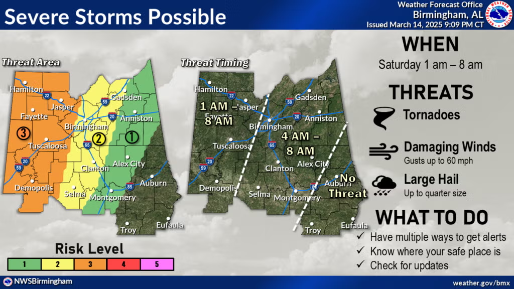
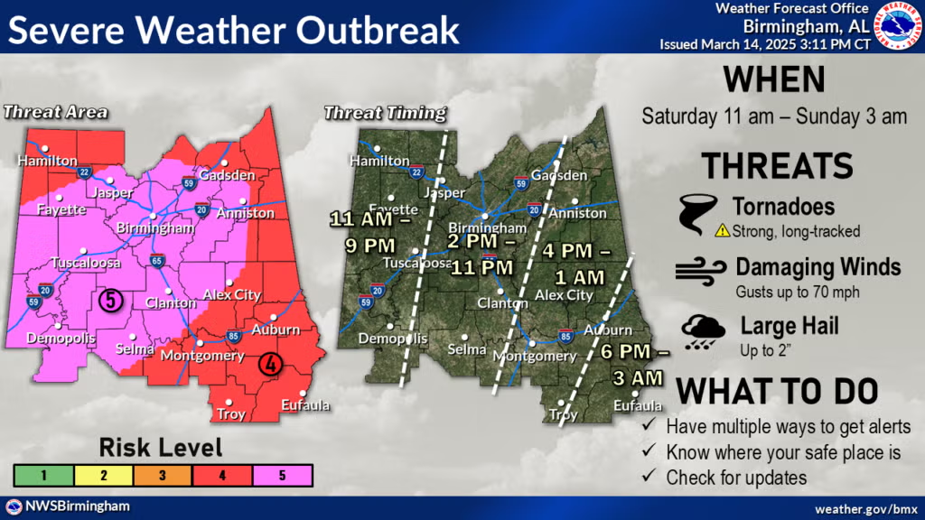
The first wave hits overnight, from 1 A.M. to 8 A.M., carrying an “enhanced” risk (level 3 out of 5). Expect tornadoes, winds gusting up to 60 mph, and hail as big as quarters. Then, from 11 A.M. to 9 P.M., the danger ramps up to a rare “high” risk (level 5 out of 5). This could bring powerful, long-lasting tornadoes, hail up to two inches wide, and wind gusts reaching 70 mph.
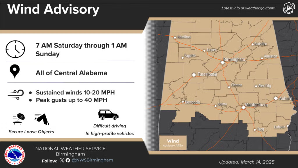
Central Alabama’s also under a wind advisory from 7 A.M. Saturday to 1 A.M. Sunday, with sustained winds of 10-20 mph and gusts up to 40 mph.
Get Prepared: Watches vs. Warnings
Not sure what all this weather lingo means? Here’s the breakdown: A tornado watch signals that conditions are ripe for twisters to spin up—stay alert and ready to act. A tornado warning, though, means danger’s imminent—a tornado’s been spotted or radar’s screaming trouble. When that warning hits, move fast and find shelter.
For University of Alabama folks, brush up on UA’s severe weather protocols now. Download the UA Safety app (available on iOS and Android) for real-time alerts on watches and warnings in Tuscaloosa County. UA Alerts will also ping you if campus is in the crosshairs, and you can tune into 92.5 FM UA Info Radio or check X, Instagram, and Facebook for updates.
Where to Hunker Down
On Campus: If a tornado watch pops up, UA’s storm shelters are open to students, faculty, and staff—on-campus or off—until the threat passes. Got a pet? The Magnolia Parking Deck’s Best Available Refuge Area (BARA) welcomes them, but dogs need to be crated or leashed and muzzled, and other animals must be in crates. Owners, you’re on cleanup duty.
Can’t reach a shelter? Head to the nearest BARA—check building emergency plans near exits or use the UA Safety app’s “explore” feature to find one.
Parking Tips: During a watch or warning, park in any legal spot near a shelter or refuge area. If decks are full, surface lots are your next bet (see the shelters page parking map). Just don’t block roads, fire lanes, or hydrants—safety’s the priority. Enforcement will only ticket for hazards during the event, and you’ll get time to move your car after the storm clears.
Off Campus: Tuscaloosa County has public shelters scattered around—find one if you’re nearby. Skip cars and mobile homes; they’re no match for a storm. In an apartment? Get to the lowest floor fast and avoid upper levels. If you’re caught away from campus during a warning, pick a sturdy building, head to the center of the lowest floor, and steer clear of windows.
After the Storm Passes
On campus, University police and staff will jump into action to assess damage—report anything you spot to UAPD at 205-348-5454. Off campus? Watch out for downed power lines and avoid damaged buildings until officials give the all-clear. Call 911 for emergencies. Once you’re safe, let loved ones know via text, call, or social media.
For more tips, visit the Office of Emergency Management’s website or tune into 92.5 FM. Stay sharp—this weekend’s weather isn’t messing around.


